Today’s piece of transport infrastructure is both unusual and attractive. Whether it actually enhances the local environment is a whole other question, and one which speaks to our uneasy relationship with the private car and the infrastructure which supports it.
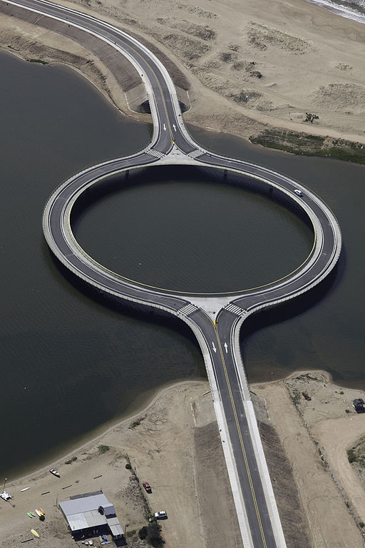
Uruguay’s 4,448-acre (18 square km) Laguna Garzón has long presented a barrier to road traffic on the country’s south east coast. The missing link in National Route 10 across the lagoon was served for many years by a small ferry, with the attendant problems of capacity and weather-related interruptions to service you would expect. The Ministry of Transport had improvements to the crossing on its agenda for many years, and early in the 21st Century finally commissioned an alternative in the form of a bridge, with Uruguay-based Rafael Viñoly Architects selected as the designer. So far, so good.
Unfortunately, the lagoon is not only very large, but is also nationally designated as an Important Bird and Biodiversity Area. Unfortunate for the Ministry of Transport that is, not the birds nor the visitors to this attractive and environmentally sensitive stretch of Uruguay’s coast. As Rafael Viñoly Architects noted, the area in which the bridge was to be built is, “popular for birdwatching and clam harvesting, and is surrounded by panoramic landscape views.”
Rafael Viñoly Architects’ solution was what the practice termed “a lagoon within a lagoon”, a bridge with a 202m-diameter (663ft) ring in the middle. The bridge attempts to minimise its environmental impact by being supported on as few columns as possible, with the ring shape reducing the shadow cast on the waters of the lagoon below. It is placed high enough over the water to allow boats to pass underneath without interruption. Sixteen concrete pillars spaced 20m apart support the ring, and the circular road layout acts as a form of traffic calming, with drivers forced to slow down to navigate the curved road, which also “encourages drivers to take in the natural beauty of the area,” as Rafael Viñoly Architects puts it. The bridge was completed in December 2015.

Footways run both sides of the bridge on the outer edge, and at the ring section there are pedestrian crossings which give access to the inner edge of the ring, where visitors are encouraged to “sit, fish, and take in the views.” I’m not absolutely sure exactly how attractive a roadside sitting/fishing/viewing area actually is, especially as there aren’t any seats provided. However, the visualisations of the bridge produced by Rafael Viñoly Architects show that a much more substantial viewing/seating area was originally planned to run the entire length of the inner edge of the ring, with plenty of seating and a roof supported on a timber frame. As it is, the reality of the completed bridge seems to have been value-engineered down from the initial concept such that there is no shelter on the inner ring, and the only thing to sit on is the concrete barriers separating roadway from footway (not recommended in any environment).
Summing up, Rafael Viñoly Architects says, “The bridge’s unusual circular road deck slow traffic and allows drivers, pedestrians, and cyclists to appreciate panoramic views to one of the most beautiful and pristine coastal landscapes in Uruguay.” This presumably works on the assumption that the best place to observe a beautiful and pristine coastal landscape not spoiled by the intrusion of National Route 10, is from National Route 10 itself.

Once again, the private car is busy transforming the world by transforming environments into places that support its continued existence and growth, even at the cost of degrading an environment that was so attractive that it encouraged people to drive there in the first place. It happens all the time, all over the world. I live near some ‘honeypot’ beaches. People want to drive there to experience the beauty of the coast and get away from the urban environment. They are so popular that large car parks have been built to serve all the cars, with the result that those beaches are now huge car parks with a strip of sand alongside. In serving the needs of people who want to drive to an unspoiled environment, the unique nature of that environment has been completely lost. But it’s now very easy to drive to those beaches and be reasonably sure that you will find a parking space, encouraging continued car access. The private car has transformed (and degraded) a natural environment for its own furtherance. You’d describe such activities as a viral or bacterial infection if they were to take place in a human body.
Even Rafael Viñoly Architects acknowledge the trade-offs at Laguna Garzón. Here is what the practice says: “Rafael Viñoly Architects accepted the commission for the Laguna Garzón Bridge on the condition that the new bridge would signal the end of the National Route 10, the main access road to several seaside resorts in the area. Firm Principal Rafael Viñoly lobbied Uruguayan government agencies to give the highway’s development power to local jurisdictions whose interests are more environmentally-centered.”
Well, maybe. I suppose it is easier for governments to accept the need for environmental responsibility once the infrastructure has been built (and, perhaps, the damage has been done) rather than accept that pristine environments are generally pristine because they are difficult to get to, especially by private car. Transport planners are apt to forget that the most beautiful form of transport in sensitive environments is no motorised transport at all.
How to find the Laguna Garzón bridge
Click here for The Beauty of Transport‘s map
Bibliography / Further Reading
Rafael Viñoly Architects’ project page for the Laguna Garzón bridge

An interesting post – thank you.
Route 10 in Uruguay has another rather unusual bridge, the Puente Leonel Viera, which crosses the Maldonado river between La Barra and Punte de Este.
It’s a stressed ribbon bridge, in which pre-cast concrete sections are held in place by tension cables running the length of the bridge. Unusually, in this case, the bridge undulates significantly along its length, with a pronounced “sag” in the middle. It looks very odd and is weird to drive over – a bit like being on a roller coaster.
Here’s a link….
https://en.m.wikipedia.org/wiki/Leonel_Viera_Bridge
Nice choice